Click on graphic above to navigate the 165+ web files on this website, a regularly updated Gazetteer, an in-depth description of our island's internally self-governing British Overseas Territory 900 miles north of the Caribbean, 600 miles east of North Carolina, USA. With accommodation options, airlines, airport, actors, actresses, aviation, banks, beaches, Bermuda Dollar, Bermuda Government, Bermuda-incorporated businesses and companies including insurers and reinsurers, Bermudians, books and publications, bridges and causeway, charities, churches, citizenship by Status, City of Hamilton, commerce, communities, credit cards, cruise ships, cuisine, currency, disability accessibility, Devonshire Parish, districts, Dockyard, economy, education, employers, employment, environment, executorships, fauna, ferries, flora, former military bases, forts, gardens, geography, getting around, golf, guest houses, highways, history, historic properties, Hamilton, House of Assembly, housing, hotels, immigration, import duties, internet access, islands, laws, legal system and legislators, main roads, marriages, media, members of parliament, money, motor vehicles, municipalities, music and musicians, newcomers, newspaper, media, organizations, parks, parishes, Paget, Pembroke, performing artists, residents, pensions, political parties, postage stamps, public holidays, public transportation, railway trail, real estate, registries of aircraft and ships, religions, Royal Naval Dockyard, Sandys, senior citizens, Smith's, Somerset Village, Southampton, St. David's Island, St George's, Spanish Point, Spittal Pond, sports, taxes, telecommunications, time zone, traditions, tourism, Town of St. George, Tucker's Town, utilities, water sports, Warwick, weather, wildlife, work permits.

![]()
By Keith Archibald Forbes (see About Us).

Part of Southampton Parish's crest, from the 3rd Earl of Southampton. His coat of arms, copyrighted by his family, members of which still exist today. Used with exclusive permission from the copyright owners. Do not copy.
![]()
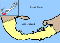
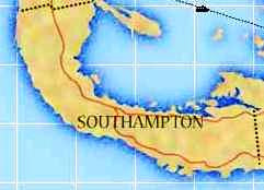 Southampton Parish, on Main
Island, is one of the nine parishes each of 2.3055 (two point three zero five five) square
miles.
Southampton Parish, on Main
Island, is one of the nine parishes each of 2.3055 (two point three zero five five) square
miles.
It was named after Henry Wriothesley, Third Earl of Southampton (1573-1624), an English aristocrat, one of the most colorful Elizabethans, the patron and friend of William Shakespeare.
He served against the Spaniards in the Calais Expedition of 1596 but in 1599 was implicated in the Essex Plot and imprisoned by Queen Elizabeth 1. Set free by King James, he was made a Knight of the Garter. He died in the Low Countries where he had gone as a volunteer once more to fight the tyranny of Spain. Always interested in overseas exploration, he was a member of the Council of the Virginia Company in 1605, the North West Company of 1612. He was one of the gentlemen Adventurers who invested in the newly formed Bermuda Company of 1615. He was the largest shareholder in the original Southampton Tribe but never visited. The major British port of Southampton, in Hampshire, is also named after him and his family.
Early Bermuda settlers called it Port Royal, instead of Southampton. This Port Royal pre-dates Port Royal of Jamaica and is why there are several references to it. The bay on the north side became a shipping center before the City of Hamilton was established.
This Parish is the second most western in direction and a good distance from the Bermuda International Airport, an expensive taxi ride. From 2001, it has a stop for Bermuda Government ferry boats. It is served by buses.
![]()
![]()
A Bermuda National Park. Added in the latter part of the year 2000. It is 1.74 hectares (4.39 acres). Also the sign on some buses, meaning this is as far as they go.
![]()
Off Middle Road, on Industrial Park Road. Telephone 238-8800. Not a golf course but a driving range.
![]()
![]()
![]()
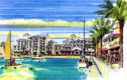
Bermudas biggest superyacht marina. Opened April 15, 2017. The 110-berth development featured a marina for up to 33 superyachts, as well as 80 berths for the exclusive use of Ritz-Carlton Reserve Residence owners from the new hotel also to be built on the site and a yacht club. The marina was finished in time for the start of the Americas Cup yacht races in June 2017. The completion of phase one of the marina development included the construction of the berths and mooring spaces. Structural completion included installation of the all the docks, including piles, pontoons, fingers and electrical components. It was hailed as a key step in the development of Caroline Bay, a five-star luxury hotel, residences and marina project at the former Morgans Point military base in the West End. When complete, the site will also feature restaurants and upmarket retail stores.
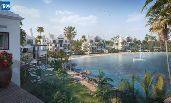
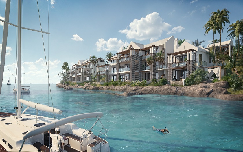
Caroline Bay's The Cove, A Ritz Carlton Reserve hotel, Bermuda, coming soon, it is hoped
Caroline Bay's The Cove was the name devised in April 2016 for the upcoming new luxury 5 star Ritz Carlton hotel and 35 homes development being built at Morgan's Point. It was expected to open in by or in 2018 but has been delayed by severe financial setbacks since 2007. Then, intended were 149 Ritz-Carlton Reserve Residences at the renamed Caroline Bay resort. Prices for homes on the site, which range from two-bedroom homes up to four-bedroom penthouses, were priced from $2.5 million to $3.9 million. The 79-room Ritz-Carlton Reserve hotel will form the centerpiece of the 182-acre site, with other amenities including two pools, beaches, a spa, a childrens club and water sports activities. The last new development that Bermuda saw was the Fairmont Southampton and that was completed in 1972. Morgans Point, the former US Naval Annex, was left derelict for more than two decades after the US Navy ended its presence in Bermuda. The site was taken up by Morgans Point Ltd. The Cove was designed by SB Architects.
![]()
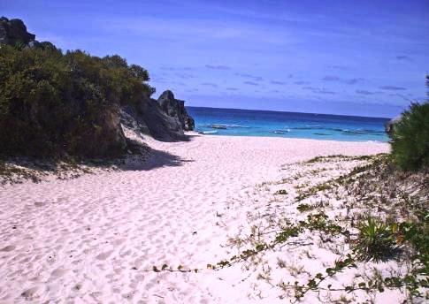
South Shore, off South Road. A spectacular South Shore Park Beach situated mostly in this Parish but also partly on Warwick's western boundary adjacent to and east of Horseshoe Bay. Bus route 7. A favorite of Bermudians. Walking trail to Horseshoe Bay (less than one mile but may seem longer in Bermuda's June-September combination of heat and humidity) and other South Shore beaches. Bounded by cliffs on both sides. Bathrooms (toilets) but no other facilities. This beach almost disappears during storms and high tides, so should be sought only at low tide. The sea is not usually calm but fine for swimmers close to the shore. An unusual coral wall stretches above the water and across the beach, essentially splitting the beach in two. It gets the name not from the Charlie Chaplin family (which at one time did own some Bermuda real estate) but a much earlier person by that name. He was Edward Chaplin, Sr, a 20 year old colonist in 1635 aboard the ship Dorset. He later became prominent in island affairs. He was a Lieutenant in the local militia and was one of those involved in the 1650s for re-arming the island's British Army-built forts. As a reward he was given Share 24 of Warwick which included this bay which thereafter became (and is still known as) Chaplin Bay even though the family in Bermuda died out in the mid 1800s.
![]()
South Shore, off South Road. Small but beautiful public beach. Gets deep quite suddenly. A Bermuda National Park, ocean- side with rest area. Good for sunbathing, snorkeling and other water sports, with boiler and other reefs, no corals. Bathrooms (toilets) nearby. Also with picnic tables and parking areas. Ruined British Army-built fort nearby. Bus route 7. A summertime favorite of locals because of its beauty, with an old fort on the premises including a '1612' date marker.
Church Bay beach
![]()
A recreational area. The name dates back to the late 1940s and 1950s when many motorists lost their lives on the stretch of the Middle Road in the area.
![]() .
.
![]()
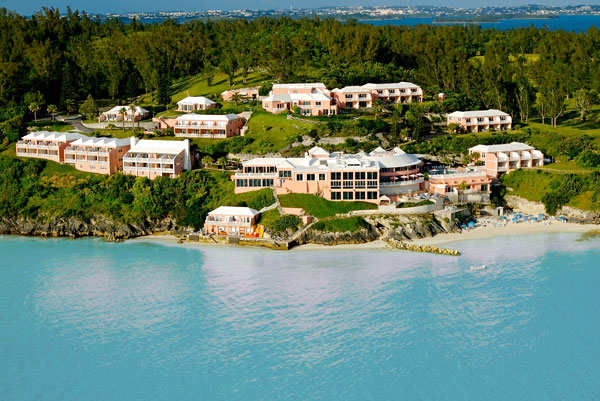
593 rooms. South and Middle Roads, Southampton Parish. Or airmail at P. O. Box HM 1379, Hamilton HM FX, Bermuda. Reservations 1 ( 800) 223 1818 in the USA or ( 800) 268 7176 in Canada or (441) 238-8000 directly. Fax (441) 238-8968. E-mail southampton@fairmont.com. 593 rooms, 1500 guests, 853 staff. Newport Room 239-6964; Rib Room 239-6966; Tennis Club 239-6950; Waterlot Inn 239-6967; Whaler Inn 239-6868; Wickets Brasserie 239-6969; Windows On The Sound 239-6963. Taxi fare from/to airport from $35 per taxi for 1-4 passengers or $45 for 5-6 passengers. Near the 7 and 8 bus routes.
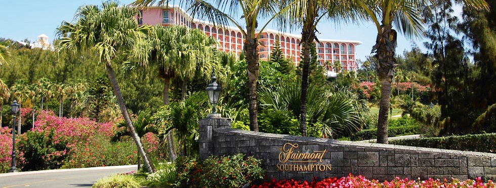
 Originally called the
Southampton Princess, it has hosted some of the world's best-known and
wealthiest celebrities and dignitaries. Guests have included the Saudi royal
family's stay in the late 1970s, which saw fresh lamb's milk flown onto the
Island every day for more than week; Bill Cosby and his wife; US presidents,
including George Bush senior; British Prime Minister Tony Clair and Cherie Blair; The Queen and Prince Philip
(though they always stayed at Government House); James Belushi.
Originally called the
Southampton Princess, it has hosted some of the world's best-known and
wealthiest celebrities and dignitaries. Guests have included the Saudi royal
family's stay in the late 1970s, which saw fresh lamb's milk flown onto the
Island every day for more than week; Bill Cosby and his wife; US presidents,
including George Bush senior; British Prime Minister Tony Clair and Cherie Blair; The Queen and Prince Philip
(though they always stayed at Government House); James Belushi.
The four-star hotel opened with 600 rooms but now has 593. Millions of dollars have been spent on renovations over the years and the hotel now features a state-of-the-art spa, though the footprint of the site remains the same as in 1972, when then-Governor Lord Martonmere performed the official opening. The Southampton Princess was the brainchild of American businessman and shipping magnate Daniel K. Ludwig, who also owned its sister property, the Princess Hotel in Hamilton. Canadian Pacific Hotels bought both properties in 1998 and took over Fairmont Hotels and Resorts the following year. The hotels were then renamed the Fairmont Southampton and the Fairmont Hamilton Princess.
2019. December 20. The new owners of the Fairmont Southampton will spend more than $25 million in upgrades to the 47-year-old hotel. Miami-based Gencom, which already owns Rosewood Tuckers Point, said its 2017 venture into the islands hotel business had inspired them to double down on Bermuda. Alessandro Colantonio, Gencoms executive vice-president acquisitions and capital markets, said: We are really happy to be investing again in this destination. We couldnt be more pleased in the community, and everyone we have been in talks with has been fantastic. We are happy to be a part of Bermuda and to help with the islands long-term success and we thought this was really the right time to double down on Bermuda. The company spent $25 million on renovations to the Hamilton Parish Tuckers Point resort. Mr Colantonio said the company planned to spend even more on work at the Fairmont Southampton, the islands largest hotel.
2019. December 20. The Fairmont Southampton hotel has been sold to a Miami-based company, it was announced last night. Karim Alibhai, the founder of investment firm Gencom, said he planned an ambitious programme of renovations at the landmark hotel. Mr Alibhai added: Acquiring Fairmont Southampton demonstrates Gencoms steadfast commitment to supporting the long-term growth of Bermudas tourism and hospitality sector. The island is located less than three hours from most major North American cities, making Bermuda a rare and accessible paradise. With a planned restoration, we aim to create a wonderful, updated destination resort experience at Fairmont Southampton for leisure and group travellers from all over the world. Gencom, which already owns the Rosewood Bermuda resort, did not reveal the terms of the deal. But the company said in a press release that it was committed to a long-term investment in the hotel, which will continue to be managed by Fairmont Hotels and Resorts. Zane DeSilva, the Minister of Tourism and Transport, said the deal showed Gencoms commitment to the rebirth of the tourism industry. He added: We support what it means for this hallmark hotel and welcome the fact it sends a strong message to the world about Bermudas tourism investment value. Mr DeSilva shared the news in the House of Assembly last night, when he also told MPs that the first phase of the St Regis hotel development, in St Georges, was set to be completed April 2, 2021. He added: This includes both the 122-room resort hotel as well as the reopening of the affiliated Robert Trent Jones designed golf course. Kevin Dallas, BTA CEO, welcomed news of the Fairmont Southamptons sale and pledged to work to build on the hotels success.
2019. May 2. The owners of the Fairmont Southampton confirmed yesterday that they are in talks with a potential buyer. Kiaran MacDonald, the resorts general manager, said: The hotel has been actively up for sale for quite some time. We are in advanced discussions with a prospective purchaser, Mr MacDonald added he was not in a position to share details of who was involved in the sale talks and dismissed rumors that the hotel had already been sold. Gencom, a Miami-based investment firm, bought Rosewood Tuckers Point hotel in 2017 and are said to have explored additions to their Bermuda portfolio. The company owns, operates and develops real estate properties worldwide with an emphasis on luxury hotels, resorts and branded residential properties. A spokesman at Gencoms head office yesterday said the principal and founder Karim Alibhai and Alessandro Colantonio, the executive vice-president for acquisitions, and Phil Keb, the firms head of development, were traveling yesterday and not available for comment. French company AccorHotels took over Fairmont Hotels, which owns the Fairmont Southampton, in 2015. The owners are known to have been looking for buyers for the 593-room hotel, Bermudas largest tourism property. The news came as Bermudas tourism industry started a renaissance. A record total of 770,683 visitors arrived on the island in 2018, up by 84,775 people, or 11 per cent, on the previous year. The Bermuda Tourism Authority said last years tourists pumped more than $500 million into the economy. The Fairmont Southampton is considered Bermudas convention hotel as well as being popular with the tourist trade. The hotel features ten restaurants, a spa, the 18-hole, par-three Turtle Hill Golf Club, the Mid-Ocean Amphitheatre, and more than 25,000 square feet of meeting space.
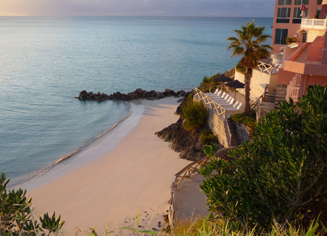
2015. December. Owned until then by Fairmont Hotels and Resorts, since then by French-owned Accor Hotels, largest hotel group in Europe. Bermuda's largest hotel, on the second highest point of Bermuda. In 1972-74, when it was built, almost 100% of the construction materials came from Canada. It is a 100-acre estate facing the South Shore ocean and Great Sound on the north side. It is a luxury resort hotel. Major improvements have included a new spa, pool and beach area. There are lovely gardens and its own challenging, executive golf course. It has sophisticated and flexible meeting facilities, a variety of restaurants and services. It was built in 1972 from scratch by its first owner, the American multi-millionaire Daniel Ludwig. Sixty percent of hotel guests are in conventions. It has received numerous Bermuda Government Tourism awards. The Princess-to-Princess (linking both the Fairmont Hamilton Princess and Fairmont Southampton Princess) ferry is very popular with guests. Nearest beach is the one belonging to this hotel, reachable by the hotel's beach shuttle. For other beaches, see beaches.
2011. The hotel tried to adapt to match the change in clientele, lowered costs for guests and offered unprecedented room discounts to attract those looking for value for money in the then-current financial climate.
2009. March. The hotel realigned its operations to meet the shift in demand from high end to mid-range visitors as the economic crisis took further effect. Previously, it focused mainly on the luxury tourist market, but the introduction of the new cost-conscious traveler in 2009 has seen the resort transform the way it does business.
2009. January. Arising from the economic downturn that has so hugely affected Americans in particular, the hotel's best clients by far, the hotel announced 35 job losses, in the first signs of recession hitting Bermuda's tourism product. Plus, it closed half of its guest rooms until April 2009. In addition, restaurants were closed on a rotating basis based on hotel-occupancy rates, until the 2009 summer season.
2008. August. Fairmont Hotels and Resorts applied for planning permission to build 130 villas on the grounds of this hotel. Some units overlook the golf course but the fairway itself remains intact. The golf course remains as a par three 18-hole golf course. The mixed-use development of fractional units, townhouses and villas only resulted in the relocation of the 14th green and tee, plus a new 18th tee and green. Since acquiring the hotel in 1998, the Fairmont group has invested $122 million in remediation work and facilities upgrades, following Hurricane Fabian. The consultants say fractional units for sale and rent are necessary to create additional product offerings for tourists.
There were eight proposed areas of development:
Golf Course: A new 18th tee, fairway and green planned, plus relocation of the 14th green and tee. But with no loss of yardage
Turtle Hill Fractional Units: 57 units housed in eight two/three storey buildings, to create a "luxury private fractional ownership club". Appealing to "upper income buyers", the units are around a private complex with arrival plaza, two tennis courts and an infinity pool.
Turtle Hill Villas: Built to the east of Turtle Hill, this accommodation consists of seven two-storey villas.
Golf Fractional Units: Located on the hillside overlooking the golf course, to the south-west of the hotel, 14 fractional units built in four two-storey buildings, with accompanying spaces for golf carts. Marketed to golfers, the units are available for home ownership.
Golf Villas: Twenty villas to the north of the golf course clubhouse, housed in seven two-storey blocks. Amenities include a swimming pool and garden, plus a new driveway providing access from Harbour View Drive.
Hilltop Villas: Ten units built in three two-storey buildings to the north-west of the hotel, with access from Lighthouse Road.
South Road Town homes: 22 townhouses in three two-storey buildings, accessed off South Road, specifically intended for sale to the local Bermudian market.
Fairmont Beach Club: The existing tennis courts near East Whale Bay replaced by additional food and drink facilities. The Beach Club has a fire pit, bar, cabanas, pool and waterslide, plus possible grotto and Jacuzzi pools.
![]()
Se under "Rockaway Ferry Stop" below, George's Bay Road. Built in 2002, now operating daily.
![]()
Accessible via Gibb's Hill and Tribe Road # 2, South Road or Bermuda Railroad Trail. It and the park (with a total extended acreage of parkland now of 3.93 hectares or 9.75 acres since the year 2000) are open to the public daily from 9:00 am to 4:30 pm. One of Bermudas leading tourism attractions, the lights focal plane is at 362 feet above sea level and aircraft can see its flashes from over 100 miles away. It towers 117 feet high from Gibb's Hill, 245 feet (35 meters) above the water, with the beacon 362 feet above sea level and the lighthouse itself 35 meters from the base to the lantern. At first it was illuminated with kerosene and wound up to rotate. Today, electricity powers the mechanism. Its maritime light can be seen by ships 40 miles out to sea and by pilots of aircraft up to 120 miles away at 10,000 feet. There is no elevator, instead 185 very steep steps, in 8 flights. Photographs and drawings are displayed on the way up. From there, see how Bermuda is not just one island but many - and appreciate why the lighthouse was built on a high hill inland so its light could be seen by ships at sea to the south and north. In both light and radar surveillance, it plays a key role in safety of ships at sea. Its Swedish built radar system covers the entire western area of Bermuda. It is connected by a microwave link to Harbor Radio (located at Fort George in St. George's Parish), the central facility for ensuring that vessels of all sizes are guided to safety in local waters instead of running aground on any underwater reefs or other hazards.
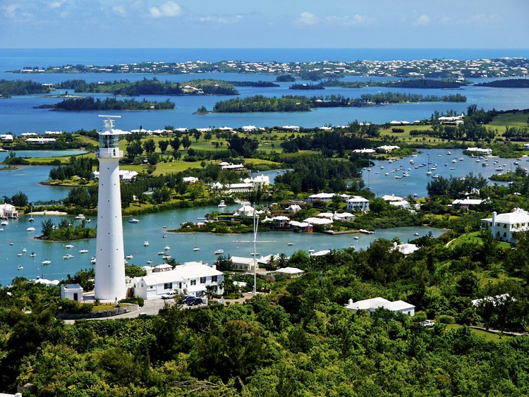
Gibb's Hill Lighthouse, Bermuda Tourism photo
 History.
The most prominent local landmark in Bermuda, it was the
second
British cast
iron lighthouse. After years of debate on whether this site or one on Wreck Hill in Sandys Parish
was more suitable, this site won. Testing included flaming barrels of tar. A proposal to
have it built went to London in the 1840's.
History.
The most prominent local landmark in Bermuda, it was the
second
British cast
iron lighthouse. After years of debate on whether this site or one on Wreck Hill in Sandys Parish
was more suitable, this site won. Testing included flaming barrels of tar. A proposal to
have it built went to London in the 1840's.
The location of 39 wrecks was cited as what a structure like this might have prevented. Approval was granted. Plates for the building were constructed in London at a cost of 5,500 pounds sterling, designed by engineer Mr. George Groves, working for the firm of Alexander S. Gordon which was awarded the contract. The plates were shipped to Bermuda, unloaded at Jew's Bay and hauled by British convicts transported to Bermuda and working in chain gangs overland and up the hill with considerable difficulty.
The first was laid on December 12, 1844, with Mr. Groves superintending a team of British engineers. They were led by Lieutenant Colonel Philip Barry who was sent out from England in 1844 as Commanding Officer of the Royal Engineers based in Bermuda.
In 1845 the building was completed with the aid of newly-arrived convicts sent from Dockyard with Royal Navy officers overlooking by sea. The Royal Navy had played a key role from the sea in determining the best place for the lighthouse to be noted by mariners.
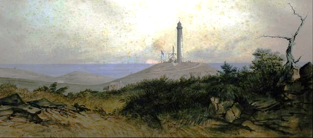
Above: 1848 image of the lighthouse, painted by then-Bermuda-based military artist Hallewell.
The structure was officially opened on May 1, 1846 with Groves in attendance. (In later life, he achieved a knighthood and immortality as the editor of the "bible" of classical musicians, the Grove Dictionary, still published today). Legend has it that when the lighthouse first went into operation, residents of the area tossed aside their whale oil lanterns and candles in the belief the big lighthouse would light up their nights forever! Some folks still refer to it the way their mid 19th century forebears did, as the "Parish Lantern." It was visited in May 1861 by Prince Alfred, Duke of Edinburgh, second son of Queen Victoria, during his six-day Bermuda visit; and in 1880 by (another) Prince Albert, 16, and Prince George, 15, sons of the-then Prince of Wales, later, Edward VII), who arrived as midshipmen on HMS Bacchante.
In 1882, on December 6, a Transit of Venus occurred, clearly visible from Bermuda for several hours. A team of British scientists and astronomers from the Royal Greenwich Observatory were sent to Bermuda to witness it. They set up camp a few weeks before the event. They were led by well-known astronomer and meteorologist John Isaac Plummer and their viewing was conducted from this lighthouse. In the USA, from its sightings there, US composer John Phillip Sousa composed the march "The Transit of Venus" in its honor.

Sousa's Transit of Venus March
August 14, 2013. The Bermuda Government announced repair work on Gibbs Hill Lighthouse. Rust had spread over the tourist attraction, with large cracks clearly visible on the lighthouses exterior. Work was to be done not immediately. Prior to the December 17, 2012 general election, the lighthouse was on the list for major upgrades by the Department of Public Lands and Buildings after members of the public expressed concern about the rusting exterior of the building. An exhaustive assessment was carried out and it was determined that around $500,000 of renovation work was required. The external painting of a structure as tall as the lighthouse requires the construction of scaffolding and the services of a highly specialized team. The government sought quotations from painters and construction companies with expertise and experience in painting and repairing tall steel structures. The work included sand blasting all of the metal surfaces and the instillation of a new guardrail on the observation deck. When re-opened, there was again be an admittance charge per adult, but no charge for children under 6. It re-opened in August 2006 after being closed for repairs, including damage incurred by Hurricane Fabian in 2003. The repairs then included replacement of the system that drives the rotating light, the exterior railing and repainting of both the interior and exterior of the lighthouse.
A good book is Bermuda Light - The Story of Gibb's Hill Lighthouse by Michael Dolding. He and his family once lived in the property below the lighthouse, now a restaurant.
![]()
![]()
![]()
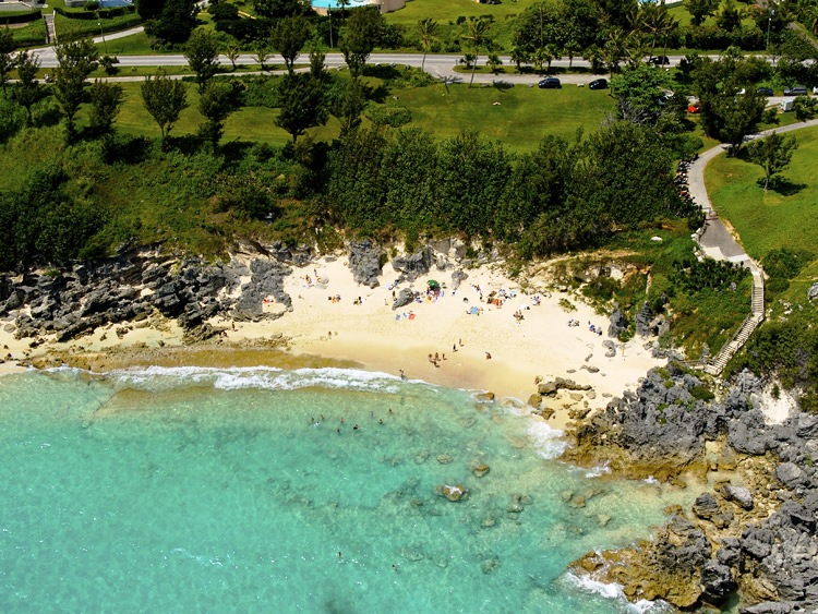
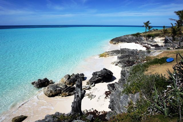
Horseshoe Bay (public, large (about 4 miles). superb. Horseshoe Road, off South Road and on bus route #7. Walk down the hill to the beach from the bus. With lifeguards on duty from May to September. Also a restaurant, changing facilities, bathrooms (toilets), parking. The best-known and one of the best Bermuda beaches. Every year it has a sand castle and sand creation competition. Best in early morning to avoid crowds. Wading pool, shallow waters for small children, good swimming and snorkeling for adults, swimmers should note swells. Many fish in waters. Beach chairs and snorkel equipment for rent. Also has nice walking trails with secluded coves nearby. Every August, with a Sand Sculpture Competition. Every Good Friday, an annual Bermuda Kite Festival is held here, with thousands of families and children participating in kite competition. Mostly locals plus some visitors bring Bermuda and other kites of all shapes, designs, sizes. Prizes are awarded by category.
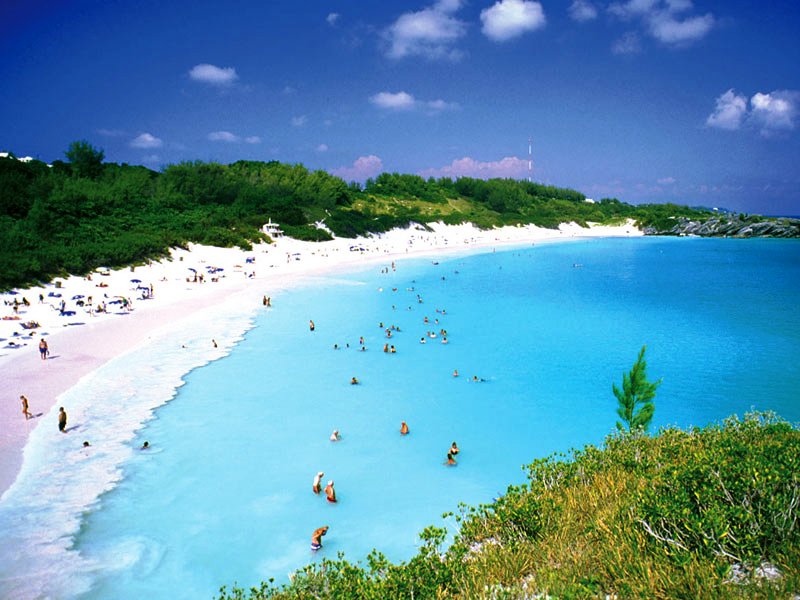
On August 7, 2012, Horseshoe Bay got WIFI. Bermuda beachgoers can now surf the web on their phone or tablet thanks to a new WIFI hotspot set up by Digicel and Transact. Customers wishing to enjoy high-speed internet as they soak up the sun are now able to do easily. The service is the first of its kind on a Bermuda beach, but unlike many WIFI hot spots on beaches in the US and around the world, its not free. Customers at the beach can log on by connecting to the internet and following the Digicel prompts and pay by credit card. Or they can buy a prepaid card at the concession stand at Horseshoe Bay. Itll cost $2.95 for an hour, $8.95 for the whole day, or $11.95 for a full week.
Photo: Bermuda Tourism
![]()
| Bartlett's | Two, just north of Middle Road, Great Sound. |
| Buck | South of Little Sound, close to north coast of the parish. |
| Fish Hook | South of East Whale Bay. |
| Five Star | Also known as Wilson's, 2 acres, one-property residential, Great Sound. Owned and lived on by Curt Engelhorn, the German billionaire. |
| Haggis | South of Riddell's. |
| Little Crumb | Between Spectacle and Perot's. |
| Perot's |
Previously known as Crumb, and Brush or Crumb-Brush. So-called for its similarity to a small, curved table brush used to sweep crumbs from a Victorian-era table. 8.17 acres, one-property residential, Riddle's Bay area, Great Sound, Southampton Parish. Historically significant. Previous owners include the one-time Huguenot Perot family who emigrated to Bermuda in the late 18th century shortly after the French Revolution (William Perot later became Bermuda's first Postmaster General and his stamps earned Bermuda a unique place in philatelic history); Miss Claudia Darrell, owner and operator of Bermuda's Waterlot Inn, later bought by Daniel Ludwig and then the Southampton Princess Hotel; Mrs. David Van Buren of New York who occupied the property in the late 1940s; Mr. and Mrs. Wallace Orr. In 1937 Mr. Orr built Perot's Manor House on this island (The house has 27 rooms, seven of which are bedrooms with en-suite bathrooms; outbuildings, huge swimming pool - at one time the largest in Bermuda - tennis court, boat house and small private beach) and from 1949, Stanhope Joell. The island was later owned for 14 years by billionaire Marion Cargill MacMillan. The property is valued at many US$ millions. |
| Spectacle | Next to Perot's, Great Sound. |
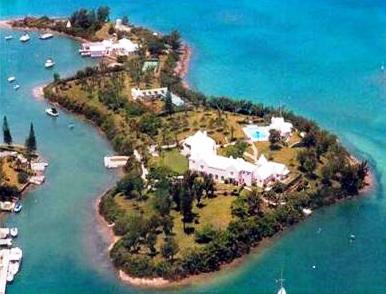
With a public wharf. A sea bay (inlet) on the Parish's northern shore. Scenic and serene, it is protected from the waters of the Great Sound by a number of islands. Worth a stop, especially if you're sightseeing by moped (it isn't easily accessible via public transport), for the fine views of the Great Sound. Access it via the main Middle Road. It's clearly sign posted, with its own little lane. The name may have been arranged as a religious counterpoint to Christian Bay, on the parish's southern coast, or a group of once-itinerant Jews who once dwelt nearby may have inspired it. The latter is more likely. Unfortunately, at that 1693 time in Bermuda's history, Jews had a harder time of it than so-called Christians, with a Jews-only trading tax plus a monthly tax for continued residency in the colony and an additional customs duty on goods they - but not others - imported. Only much later were these Bermuda censures against Jews relaxed. In 1844 the prefabricated iron parts of Gibb's Hill Lighthouse were imported into Jews Bay by the ship "John Renwick" which brought them from England. They were dragged up a hill and assembled by British convicts then undergoing hard manual labor in Bermuda, under the supervision of Royal Engineers of the British Army. The Southampton Princess Hotel's Waterlot restaurant, one of Bermuda's finest, overlooks the bay.
![]()
![]()
![]()
 A
major portion of it was being re-developed by local owners as a 5 star Ritz
Carlton Reserve Hotel Resort but work on it has stopped.
A
major portion of it was being re-developed by local owners as a 5 star Ritz
Carlton Reserve Hotel Resort but work on it has stopped.
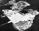
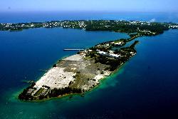
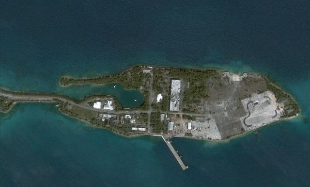
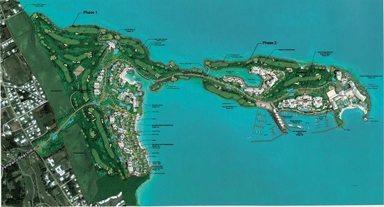
Once a collection of separate islands in the Great Sound all joined together at a cost entirely borne by US wartime taxpayers of over US$75 million at that time. Named after Morgan's Island located here until bulldozed to build the sprawling US Naval Annex during World War II, it covers 260 acres. Former US Navy facility from 1941 to 1995, variously named from US Naval Operating Base to US Naval Air Station. Over its more than 50 years of US Military occupation, thousands of US Navy personnel were stationed there, many with their wives and families.
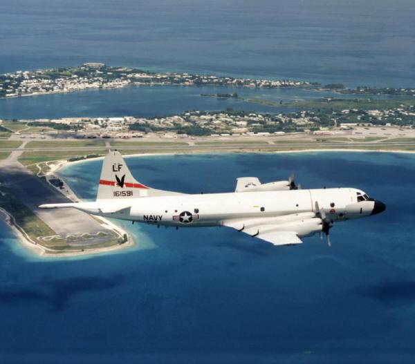
Morgan's Point with top right US Navy aircraft from this base patrolling over Bermuda
Its roads were
Boxer Road, named after a late WW2 aircraft carrier which bore the names of earlier USN vessels.
Constitution Road, named after the 44-gun frigate USS Constitution built at Boston in 1797.
Enterprise Road, after the USS Enterprise.
Essex Road, after the USS Essex.
Hancock Road, after the USS Hancock.
Intrepid Road, after the USS Intrepid.
Lexington Road. After Lexington, MA and ships by that name.
Monterey Road, after Monterey, CA and ships by that name.
Pier Road. At the main pier.
Point Cruz Road, after the USS Point Cruz.
Randolph Road, after the USS Randolph ships.
Ranger Road, after the USS Ranger.
Saratoga Road, after USS Saratoga.
Shangri-La Road, after the USS Shangri-La.
Wasp Road, after the USS Wasp.
Yorktown Road, after the ship by that name and where Lord Cornwallis surrendered British forces in 1781.
Morgans Point was until quite recently the largest piece of unutilized land in Bermuda. The former US Naval Annex, which finally ended in 1995 had been a desolate out-of-bounds peninsula, off limits to all visitors and locals after the US Navy's departure. There was huge controversy when heavy pollution was later discovered, blamed on the US Navy but in fact also partly caused by Bermudian dumping after the US Navy left.
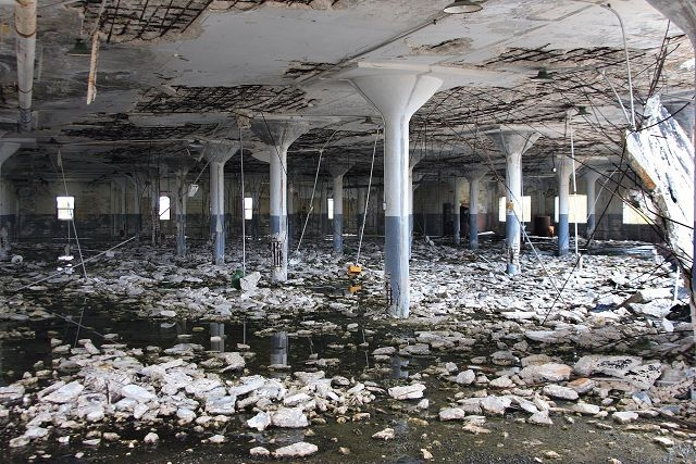
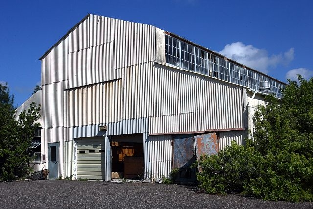
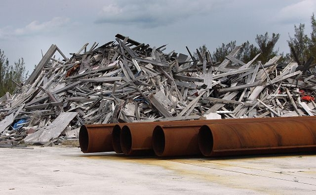
Remnants of old buildings and equipment at former US Navy Base
The cost of cleaning up the site was subsequently borne by Bermuda after the USA gave a one-time payment. Morgan's Point became the last remaining large development opportunity. The mainland area is 190 acres, with 60 acres on the peninsular joined by a causeway. It has spectacular views across the Great Sound with 5,300 meters of waterfront. The peninsular projects into the Great Sound and is all flat land. Planning permission was eventually given for an integrated resort and commercial complex.
2019. October 25. The Ministry of Finance has completed the $170 million purchase of Government-guaranteed loans at the stalled Caroline Bay resort, it was announced yesterday. The move means island-based reinsurers Arch Capital Group and Axis Capital Holdings have no remaining interest in the Morgans Point development. Curtis Dickinson, the finance minister, earlier condemned the former One Bermuda Alliance government for putting the island on the hook for the guarantee three years ago. Mr Dickinson was required to increase the debt ceiling by $250 million to $2.75 billion last month so the ministry could secure a $200 million credit issued by Butterfield Bank and HSBC to purchase the loans. He said yesterday: While the investments by Arch and Axis were guaranteed by the Government, their support for the project and Bermuda in general goes back far earlier. With respect to these project loans, until recently they had not received a single interest or principal payment. I would like to personally thank them for their patience and continued commitment to Bermuda. Preston Hutchings, the chief investment officer of Arch Capital Group, said: Caroline Bay was, and still can be, an important project to stimulate employment and tourism growth in Bermuda. We were delighted to support it, but unfortunately the developers experienced financial difficulties that to date have prevented completion of their vision. Mr Hutchings said Arch had worked with the minister to try to achieve a different result. He added: Unfortunately, that did not work out, but I would like to thank the minister for keeping us duly informed throughout the process. I wish all parties success in seeing the project through to a better result, and we will continue to be committed to Bermuda. Albert Benchimol, the president of Axis, said: The current status of this project is unfortunate, but we are grateful for the responsiveness of the minister and the Government in working towards a conclusion to this difficult situation. We made this investment to support Bermudas economic growth and we remain committed to the island and its economy. Mr Dickinson added: I would also like to thank the local banks and their teams who supported the Government by providing favourable terms and timely execution of the credit facility to help meet our short-term obligations.
2019. September 14. Morgan's Point/Caroline Bay Development Timeline over 14 years, most recent announcements first.
2019. September 12. The Bermuda Government has been forced to pay lenders for the hotel and resort at Morgans Point before the end of this month, finance minister Curtis Dickinson confirmed today. A loan of $165 million will be negotiated with local banks and paid next week, which will end the administrations plans not to raise debt this fiscal year. As reported in The Royal Gazette this morning, Mr Dickinson will now table legislation to raise the islands debt ceiling to cover the guarantee on the Caroline Bay development. The unfinished development, where construction has ground to a halt, was put on notice over the summer by Mr Dickinson. Mr Dickinson told a press conference today that Parliament had no choice but to raise Bermudas debt ceiling by $250 million this morning, and that the islands debt would be pushed to $2.75 billion. The minister laid the blame on the One Bermuda Alliance for agreeing to the $165 million guarantee on March 14, 2016. Developers at Morgans Point have failed on the terms with their lenders, who include the reinsurance firms Arch, Axis and Validus Re. Meanwhile a number of businesses are pursuing claims against the project. Mr Dickinson said there was potential for the island to suffer a downgrade at the hands of ratings agencies as a result. He said: We are responsible for resolving the negative and unfortunate outcomes of the deal negotiated by the former Government. Asked if the emergency payments meant that the development would be acquired for the Bermuda Government, Mr Dickinson said the Government had simply acquired the debt on the project as a result of its obligations. The Royal Gazette understands that the Government Loans Amendment Act will be the only legislation tabled in what is likely to be a brief session this morning at the temporary venue of Veritas Place, on Court Street, while renovations continue at Sessions House. The move comes with profound implications for the Governments hopes of balancing the 2019-20 Budget. The guarantee for the development at the former United States military base in the West End dates back to 2015, under the One Bermuda Alliance administration.
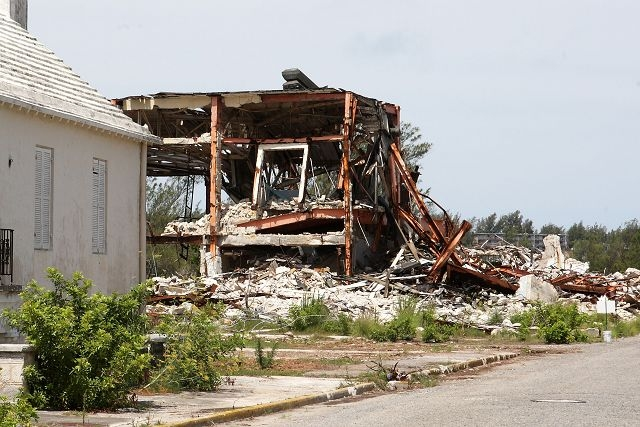
2019. August 14. Angry contractors plan to sue for millions of dollars in unpaid bills for work on the stalled Caroline Bay development at Morgans Point, two construction firms involved in the project said yesterday. The two warned legal action was imminent and one estimated that between $5 million and $10 million was owed to about 25 firms. One said the majority of the contractors had taken legal advice on an action against Brian Duperreault, the chairman of Caroline Bay Limited. He added: The feeling is that Mr Duperreault could easily pay off the contractors and call it a day. He highlighted a scaffolding supplier owed $170,000 who was now struggling to pay his childrens school fees. He said: Its always the small guy who gets hit the most. Its been six months of just empty answers, nobody is saying the right thing and guys have realised they have no recourse. Another contractor warned: Its imminent. Writs will be dropped in a matter of weeks. There is a majority team that has taken advice and another splinter group thats taken different advice, but Im sure everyone will join in on the action. He said one contractor was owed more than $1 million. There are some in the range of $300,000 to $500,000 and a lower tier within $100,000. All in all, it could go to $5 million to $10 million. He added: There are people who have missed mortgage payments and cant make insurance commitments because of that development. The development on the former United States military base was put on notice last month by Curtis Dickinson, the Minister of Finance, who told the House of Assembly that the economics of the development must be recast. Both contractors said the project had been poorly managed and had run short of finance on a regular basis. The Ritz-Carlton Caroline Bay hotel resort at Morgans Point was heralded as a bonanza for Bermudian firms at its groundbreaking in 2016. But Parliament heard last month that developers had advised the Government in February 2018 of significant financing issues that jeopardized construction. Work on the hotel phase was halted in March last year, but limited work continued on the sites residential units. The two contractors who spoke to The Royal Gazette said work at the site had been at a standstill since late last year. One said that several residential units were unfinished and that metalwork was at risk of rusting because of the salt air. He added: I dont think all the windows are in place. There was a lot of metal used in the interior. The second said: Some of whats there will have to be redone. The man continued: Anything exposed to the elements, whether its foundation with rebar or the windows and doors and exterior items sitting with no service and maintenance. If its not being used, it will deteriorate. A third contractor said the site was in varying stages of completion with some buildings with no roof and some metal studs exposed to the elements. He added: A few of the units are fully complete and even furnished for show. And there is everything in between. The contractor said the site had components that are just sitting there not being used, including electrical, plumbing and heating, ventilation and air conditioning systems, doors and windows. He added: With no use or maintenance happening, for sure product is deteriorating. Mr Dickinson highlighted Caroline Bays reliance on a guarantee from the Government to the tune of $165 million last month. Caroline Bays board announced in June an agreement which will provide the financing to continue construction. But Mr Dickinson told MPs that a term sheet or draft terms of agreement do not represent irrevocable financing and should not be termed as such and said the development needed to be devised with a realistic view of the world economy. Neither Mr Duperreault nor a Caroline Bay spokesman responded to a request for comment yesterday.
2019. July 12. This stalled hotel development in the West End needs a major rethink, the finance minister said today. Curtis Dickinson told the House of Assembly that the Caroline Bay project, at Morgans Point in Southampton, had to be recast and devised with a realistic view ... Mr Dickinson said: The land at Morgans Point continues to represent an important opportunity for Bermuda to renew its claim to being a luxury destination. The economics of the development must be recast and devised with a realistic view of the world economy and the value proposition we need to present in order to be successful in tourism, business and economic diversification.. This opportunity is too important to squander. We do not do justice to the people of Bermuda by continuing to shore up a vision that no longer matches reality and which cannot be sustained on any applicable metrics. It is well past time to approach this development differently. Mr Dickinson said earlier that the former government and the developers wanted to renegotiate the terms of its financial agreement as long ago as 2013. But he added: What the people of Bermuda did not know was that even before the marina had opened, the Caroline Bay project was experiencing difficulty. This had to have been known to the then Cabinet and the developers who persisted in providing public updates on the project which were inaccurate. He added that in early 2018 the developers asked to meet with the then Premier and Minister of Finance to advise that there were significant funding issues and that in all likelihood work would slow down and eventually cease without an injection of capital. Mr Dickinson said that Caroline Bay had announced it had secured financing, but that any offer had to comply with regulatory requirements and get the approval of the Government of Bermuda who, through the terms of the guarantee, is a full partner at the table in matters related to the financing of this development. He added that a term sheet or draft terms of agreement do not represent irrevocable funding and should not be termed as such. Mr Dickinson said that reports that work had stopped at the site and that contractors and sub-contractors had not been paid were disturbing, although that was not a Government responsibility. He highlighted that much of the lending for the construction of the development was founded, unfortunately, in a Government of Bermuda guarantee to the tune of $165 million. Mr Dickinson said that the Government would support developments that provided investment opportunities for Bermudians, employment, growth for small and medium-sized businesses and an increase in economic activity arising out of a sensible, fair immigration policy. He added: Where these ideals are embraced by developers, existing or prospective, we are open to working together.
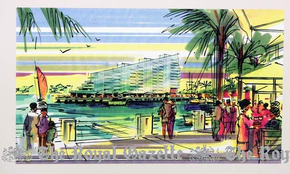
2019. July 4. Construction firms remain unpaid for their work on the stalled Caroline Bay hotel and homes development, two sources said yesterday.
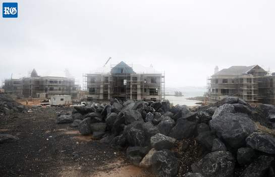
Construction as at July 4, 2019
One contractor, who asked not to be named, said he had heard nothing official and received no money. The news came three weeks after the developers of the West End resort on the site of the old Morgans Point US military base, Caroline Bay Ltd, announced an agreement to refinance the project. The contractor said any refinancing agreement would probably be provisional as a new Special Development Order, which would have to be backed by Parliament, would be needed to finalize the arrangement. ZBM reported on Tuesday that early financial backers of the project, Arch Reinsurance and Axis Capital, were unhappy with the refinancing and wanted to pull out. The firms were said to have taken on lawyers in a bid to recoup their investments. The contractor said: It will probably be the same for Arch and Axis, after radio silence at Caroline Bays end, they have run out of patience. He added: Not much has changed. The only information I received from the developers was that they had signed a new deal. More than 25 sub contractors are said to be owed money for the development, which also includes a superyacht marina, as well as a Ritz-Carlton hotel. Caroline Bay Limited announced last month that they were to obtain new backing. New financing was said to be in the works from a British-based financial services group, Ma Neil. Both Arch and Axis declined to comment last night. The developers did not respond to a request for comment by press time.
2019. June 15. Construction will proceed at the Caroline Bay residential development at Morgans Point under an agreement to revive its financing, the developers announced yesterday. It came the day after Curtis Dickinson, the Minister of Finance, sounded the alarm over a standstill in financing for the development. Mr Dickinson said the Government faced risk from its $165 million guarantee on the project. The development is part of a complex at the former United States military base, which was downscaled last year after costs outpaced its financing. Contractors linked with the project have gone unpaid, sources told The Royal Gazette this month. A spokesman for the developers said: Caroline Bay Limited, its board of directors, and board chairman Brian Duperreault, announced today that it has entered into an agreement which will provide the financing to continue construction of the Caroline Bay development. Since the outset of this project, our commitment to and confidence in Caroline Bay has been steadfast. We appreciate the patience that our construction partners have shown and are grateful for the ongoing co-operation and assistance of Government. We look forward to continuing the work at Caroline Bay. The developer declined to elaborate on the source or amount of the financing.
2019. June 14. Taxpayers could be left with a multimillion-dollar bill for the Caroline Bay residential development at Morgans Point, whose financing has reportedly ground to a standstill. Should the project go unfunded, we will be on the hook for $165 million, said finance minister Curtis Dickinson, who reminded at a hastily called press conference yesterday that the Government had signed on as a guarantor under the One Bermuda Alliance administration. Genuine efforts by the developers have been made to secure financing and these efforts are ongoing. In the interim, the principals of the company have continued to fund their obligations mindful of the importance of keeping some work going on at the site. This funding appears to now be at a standstill. As such, this accounts for the sums owed to contractors and subcontractors who have, in good faith, done the work required. Understandably, some have now lost their patience. However, in addition to the issues surrounding non-payment to contractors and subcontractors, I have a wider concern based on my responsibility to safeguard the public purse, and to avert the risk to which the Bermudian taxpayer has been exposed, first, by the former government, and now, by delays in the project. Craig Cannonier, the Leader of the Opposition, warned against pointing fingers. Mr Cannonier said: Lets get everyone working again on this project. He added that the guarantee had been provided if all else failed. Mr Cannonier said: That does not mean that at every hiccup the project has that Government needs to pay out. An agreement was made. However, Caroline Bay must do all it can to secure financing. Had a guarantee not been provided, it may not have received the support it has been given up until now. Both the OBA and Progressive Labour Party have shown tremendous support for the project and what is needed now is to ensure we all work together to get things moving again. One of the contractors for the West End development said that he was still owed not insignificant sums. We did grow impatient, said the man, who spoke to The Royal Gazette on condition of anonymity. We also recognize that the best hope for it ending well is that a new deal gets done so that the project can continue. The contractor added that potential new investors had given some assurance that funding for the development could be revived. He pointed to similar scenarios at Tuckers Point and at Newstead Belmont Hills, where the developments were unable to meet financing targets, causing investors to step in and put the projects into liquidation. He said: A lot of debtors were left holding the bag. The difference with this project is that the Government has guaranteed this sum. That is why financing needs, really badly, to come off. He added: The potential investors feedback on dealings with the Government were that they had been professional and extremely diligent. Construction was downscaled at Caroline Bay last year when costs overtook financing. Mr Dickinson said the Ministry of Finance was taking advice, and had met with Caroline Bay Development principals last Friday to discuss the advanced stage of negotiations for project funding. We are doing everything prudent to protect the Governments position, he said. There is much more to be done, however, to first secure financing to complete the project and to ensure a successful conclusion of the construction phase of the project. Asked by The Royal Gazette whether a scaled-down version of the development was under consideration, Mr Dickinson said: The developers are looking at a number of potential alternatives looking at the project as originally contemplated and also the potential of revising it. Mr Dickinson also said he wished to deal with speculation that the Government was preventing the deal from being finalised. A ZBM News report on Wednesday suggested that Cabinet was sitting on approval for licences in relation to financing and immigration. The finance minister said: I am not allowed to discuss Cabinet deliberations, so I wont. I am not aware of any delays on any applications with respect to licences that have been delayed or even submitted. A series of crunch talks with developers took place in February 2018 based on a forecast that work on the site was likely to stop, workers could be laid off and contractors not get paid. Mr Dickinson said: The persistent demands of the Government was that this could not be allowed to happen, as this country could not then, and cannot now, afford to see more Bermudians out of work. As part of the process to shore up the management of the project and other aspects of the operation of control of the development, the Government mandated changes to the corporate governance of the development company, and the marketing of the reconstruction unit was made the responsibility of a strengthened, more experienced team of realtors. While work continued at the site, the pace and scope consistently reduced to the point where it is now stopped altogether.
2018. March 27. The board of a stalled hotel construction project at Morgans Point has been changed as Government said it was in discussions with the developers over their need for more finance. Craig Christensen and Nelson Hunt have quit the board of Georges Bay Ltd, an arm of Morgans Point Ltd. Andy Burrows, chief investment officer of the Bermuda Tourism Authority and Nancy Duperreault, wife of board chairman Brian Duperreault, have replaced them as directors. David Burt, the Premier and Minister of Finance, said: This project is an important one for Bermuda and the Governments principal objective is to protect the taxpayers of this country in light of the existing Government Loan Guarantee of $165m. We now understand that Georges Bay Ltd have experienced difficulties with certain requirements of the loan guarantee agreement since June 2017 and so some restructuring of the Board and the approach to this project was suggested and changes have been made to the Board of Georges Bay Ltd. Mr Burt added that Mr Burrows appointment would ensure the Governments interests are safeguarded during this critical phase. The news came after The Royal Gazette exclusively reported on Tuesday that work on the hotel phase of the resort, due to be run by Ritz-Carlton Reserve, had been suspended for financial reasons, a move that affected about 150 workers on the site. A spokesman for Georges Bay Ltd said: First-phase construction activity at Caroline Bay has been reduced ... due to construction costs outpacing the existing financing of the project. He added: Georges Bay Limited is working to strengthen and extend the project financing so that construction can resume to prior levels as soon as feasible, and is committed to resuming the prior pace of first-phase construction once the necessary financing is in place. The resort and residential project owner looks forward to the successful completion of this unique Bermudian destination resort and residential project at Caroline Bay. The spokesman said the company appreciated the engagement and ongoing support shown by the Government and that hotel giant Marriott International, parent of Ritz-Carlton Reserve, that it remained committed to the development. Mr Burt added: There is a significant human element to our discussions also and that surrounds the hardworking men and women whose hours may have been cut or employment jeopardized by this reduced work stream. As a Government, we will keep their livelihoods at the forefront of our discussions and we will do all that we can to minimize the impact of this necessary action on them and by extension their families. With a restructured board and more direct Government coordination we will maintain strict oversight of the management of this project as the new leadership team strengthens and extends the projects financing. The first phase of the development, branded as Caroline Bay, includes 35 Ritz-Carlton Reserve residential units and a 79-room Ritz-Carlton Reserve hotel. He added: The hotel remains an important priority and will receive ongoing work within current financial resources. Most construction will now focus primarily on completion of the first residential building. Construction will include that building plus the utility infrastructure for it, the road access from Middle Road down to the residential site area, landscaping, parking, and beach. Jamahl Simmons, tourism minister, said: This is a location of great promise and we believe that a formula can be identified quickly to resume the pace of work on the development. Ultimately, Bermudas product offering will be enhanced by this developments completion and our discussions with the company are targeted on achieving that result.2018. March 27. Work at a resort development at Morgans Point ground to a halt yesterday after workers were told the hotel construction phase was on hold until further notice. About 150 construction staff were affected by the decision. The news came after three different contractors contacted The Royal Gazette about the decision, said to be driven by the need to strengthen and extend financing for the development. Construction will, however, continue on residential units at the resort, which is being built on the brownfield site of the old US Naval Annex in Southampton. Charles Dunstan, president of the Construction Association of Bermuda, said: We have been told that the hotel portion is being suspended for the time being. He added that work will continue with only limited work to take place on the residences. One contractor, who asked not to be named, branded the sudden shutdown as ludicrous. He said: I thought it was a joke. We heard this morning that work needs to be suspended by the end of the day. These people have families. Another contractor claimed that the managers of the project had not sold enough residences to continue financing the project. Mr Dunstan said that the economic bubble generated by the 35th Americas Cup may have led to unrealistic expectations. He added: Its interesting that theyve gotten so far down the line. Usually if they stall, it happens in the initial phases. Mr Dunstan said: I cant imagine they could afford to leave it sitting there for any length of time they need to move it forward in some way. He added that the workforce were taken by surprise by the news. Mr Dunstan, who is also managing director of construction firm Kaissa, said: Yes, I would say so. Having been in this industry for 30 years, Ive seen these things happen. The news has come as a blow to construction staff including some of his own workers. Mr Dunstan said: These are skilled guys for the most part. There isnt going to be a lot of work for them. This is a big project, a major deal these sort of large hospitality infrastructure projects are large scale for Bermuda and they absorb a lot of resources. For one to stop like this is not good. The hotel, with 79 suites, two of them presidential suites, is scheduled to be operated by the upmarket Ritz-Carlton Reserve brand. The directors of Morgans Point Ltd, including chief executive Craig Christensen, could not be contacted. The Morgans Point development was hailed as a major boost for the islands struggling construction sector.
2016. October 3. What was once the Navy pier at Morgans Point has now been designated as a new seaport a move which is expected to speed up development of the planned luxury resort on that land. Morgans Point Ltd CEO Craig Christensen said one of the main benefits of a seaport would be the ability to get both heavy machines and certain oversized aggregate and cargo on land as some of it was too large for travel by road. A port licence was granted today by Government in conjunction with the United Kingdom. It will be the first official Bermuda Port Facility situated on private property. The designation was granted by the UK Department of Transport. Senator Michael Fahy, Minister of Tourism, Transport and Municipalities, said: This licence is based on Morgans Point Limiteds efforts in providing a successful Port Facility Security Plan that has now been approved by the United Kingdom Government. Morgans Point now joins all maritime seaports in Bermuda as part of the International Maritime Organisation. Sen Fahy presented the certificate of Port Facility Security Plan Approval to Mr Craig Christensen earlier today. Mr Fahy added: This is a significant achievement for Morgans Point, but also a great opportunity to help you expedite your plans to build the first class facilities in the west end. I must congratulate you for the continuing hard work. This great news means further progress for Morgans Point and further progress in the redevelopment of Bermuda. The licence will allow ships to come directly to the Morgans Point seaport during construction at the site. Mr Christensen said: Morgans Point Development identified the former US Navy pier as a potential asset that could be used in the forward planning of the property development in 2014. After careful review, the company decided to begin studies on the pier and the potential value of having it used as a commercial port of entry. The pier was included in the plans for the construction storage and management area (also known as the lay-down area) to be used by the General Contractor. The company began the journey of applying for a Port Facility Operations Licence with the Department of Maritime Security of the Government of Bermuda and with the Department of Transport from the United Kingdom Government. One of the critical factors impacting development plans was getting both heavy machines and certain oversized aggregate and cargo over the road as some of this was too large for travel over the road. Having a working pier would remove this problem for the development for Morgans Point. Morgans Point determined that having this licence would bring significant value to the project and reduce development cost as shipments could be delivered directly to the site. Next month, Morgans Point will be receiving their main part of their Marina for Caroline Bay and will be delivered directly to the site. Morgans Point is most pleased to have been granted a Port Facility Licence from the Department of Transport in the UK and look to use this opportunity to increase project efficiency and cost savings for the new high end hotel and residences.
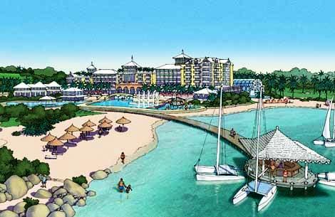
Morgan's Point causeway to Tucker's Island, artist's impression
Morgan's Point hotel development planned
![]()
 Closed in July 2007 after
having been one of the very best small hostelries in Bermuda. A lovely
4-acre estate with beach frontage. Before
July 2007 it was the much-liked, private, exclusive, romantic but also
family-friendly Munro Beach Cottages, nestled between the world-famous Port
Royal Golf Course and it's own lovely private beach, Munro Beach, at Whitney
Bay. They were sold by the Munro family to American real estate investor Sam
Byrne who hopes to develop them. The investment firm Mr Byrne founded,
CrossHarbor Capital Partners, specializes in real estate investment and
distressed loans. At the time of the property purchase, CrossHarbour managed $5.5 billion in assets for its own account and on
behalf of pension funds, and institutions. The 5-acre premises look out
westerly on the Atlantic Ocean guaranteeing spectacular sunset views. There were
various types of accommodation, all with ocean views, air conditioning fan, TV,
radio and safe. The units consisted of a bedroom/living/dining room with
separate kitchen and bathroom with shower and tub. The kitchens were fully
equipped with refrigerator, microwave, stove, oven, coffee percolator and
toaster. Barbecues and a daily maid service were also provided. Munro Beach
Cottages were quite secluded, but that was one of their main selling points. It
was a 1km walk to the bus stops on Middle Road, but guests received a
complimentary lift to a place to hire a scooter or moped.
If they did not fancy their own cooking every night inside or using the barbeque
facilities provided then several were close by, so are tennis courts and
water sports. A unique feature of the beach
was that at low tide it was possible to wade out 300 feet to the reef line.
Closed in July 2007 after
having been one of the very best small hostelries in Bermuda. A lovely
4-acre estate with beach frontage. Before
July 2007 it was the much-liked, private, exclusive, romantic but also
family-friendly Munro Beach Cottages, nestled between the world-famous Port
Royal Golf Course and it's own lovely private beach, Munro Beach, at Whitney
Bay. They were sold by the Munro family to American real estate investor Sam
Byrne who hopes to develop them. The investment firm Mr Byrne founded,
CrossHarbor Capital Partners, specializes in real estate investment and
distressed loans. At the time of the property purchase, CrossHarbour managed $5.5 billion in assets for its own account and on
behalf of pension funds, and institutions. The 5-acre premises look out
westerly on the Atlantic Ocean guaranteeing spectacular sunset views. There were
various types of accommodation, all with ocean views, air conditioning fan, TV,
radio and safe. The units consisted of a bedroom/living/dining room with
separate kitchen and bathroom with shower and tub. The kitchens were fully
equipped with refrigerator, microwave, stove, oven, coffee percolator and
toaster. Barbecues and a daily maid service were also provided. Munro Beach
Cottages were quite secluded, but that was one of their main selling points. It
was a 1km walk to the bus stops on Middle Road, but guests received a
complimentary lift to a place to hire a scooter or moped.
If they did not fancy their own cooking every night inside or using the barbeque
facilities provided then several were close by, so are tennis courts and
water sports. A unique feature of the beach
was that at low tide it was possible to wade out 300 feet to the reef line.
Munro Beach, Whitney Bay
![]()
Pompano Beach Road, Southampton Parish. Reached from Middle Road. Located west of and not far from the Port Royal Golf Course. Phone (800) 343-4155 in the USA or Canada or (441) 234 0222 directly. E-mail info@pompano.bm. Offers all-inclusive rates on application. 74-room hotel, family-owned since 1956, originally as Bermuda's first fishing club, named after the pompano game fish prolific in these parts. It has expanded appreciably since. It celebrated its 55th anniversary in 2011. Has many repeat guests and long-serving staff. Managing Director Tom Lamb III and his brother Larry are owners Offers dramatic ocean views from the main clubhouse and all guest rooms. With two fine restaurants, pool, its own private South Shore beach, fitness center, bar and much more. A spectacular location, in gorgeous turquoise waters, for the non-disabled. The two tennis courts are clay. It is on its own private road well away from all the noise of traffic, so it offers peace and tranquility. The 8 bus route is on the main Middle Road a mile away and if you stay here a courtesy shuttle bus from the hotel will take you there or collect you to and from the bus stop at the junction of Middle Road and Pompano Beach Road.
Pompano Beach. Private. Spectacular reef swimming in beautiful waters for guests. All references to "Pompano" point to a tasty game fish, the Pompano (Trachinotus glaucos) common in or near Bermuda coastal waters in the summer months, especially in this area. These game fish put up a mighty fight before being caught. They are shiny white when hooked and are often almost invisible when viewed in strong sunlight against the sandy seabed of inshore waters.
Pompano Beach
![]()
Government-owned. 18 holes. 5 Middle Road, Southampton Parish, SB 02. Mailing address is P. O. Box SN 189, Southampton, Bermuda SN BX. E-mail prgc@bermudagolf.bm. It opened in 1970 as a Robert Trent Jones-designed 18 hole, 6,561 yards par 71 public course. Re-opened in January 2009 after a $14 million renovation of the 37 years old course including increase of the course yardage by 281 yards to 6,842 yards. Phones: Office 234 -0974 (fax) 234-3562. Pro Shop 234-0972; Tee Times 234-4653; Golf Pro (fax) 234-3630; Maintenance 234-1182; Restaurant/Bar 234-5037; Tennis Courts 238-9430 or 238-9070. It hosts many tournaments and has been the home of the Bermuda Open. Sunset golf is from 4:00 pm with a reservation. For visitors who arrive on one of the cruise ships, the closest cruise ship berth is Dockyard, about 8 miles away. Buses go to nearest stop about 600 yards away.
This is the highest-rated of Bermuda's two government-owned and run courses and one of most expensive in the world. More rounds are played here than on any other Bermuda course. The signature hole has been the 176-yard, par 3 16th, the small green of which, perched on the edge of the coastal cliffs, has become notorious. Drive too far left and the ball ends up in the ocean. Site of the October 2009, 2010 and 2011 PGA Grand Slam venues. With these in mind, all the greens were rebuilt, a huge amount of earth was moved by bulldozers, new sand put into trickier bunkers, cart paths repaved and a landscaping project completed. The reverse osmosis plant produces 250,000 gallons of water per day on 1,200 new sprinkler heads. There is now a fully computerized irrigation system from tee to green.
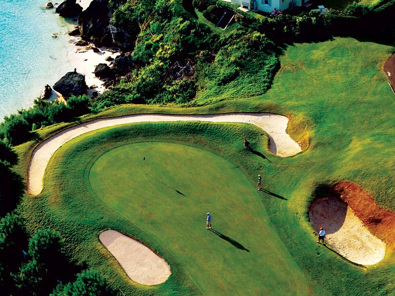
Photo: Bermuda Tourism
2019. November 5. Brendon Todd fired a record-equaling 62 to win the PGA Tour Bermuda Championship by four strokes. In carding 24 under par to almost lap the field, the 34-year-old Pittsburgh native joined none other than Tiger Woods in becoming the second player in the 2019-20 season to win an inaugural PGA Tour event. While 80 wins separate men who are miles apart on the order of golfing pedigree, they are united in having overcome great adversity. Woodss travails have been well chronicled, the most recent being another knee surgery that preceded victory at the Zozo Championship, which tied him with Sam Snead for the most PGA Tour wins at 82. But, for Todd, the road back from the yips, a run of 36 missed cuts out of 37 and a return to the lower reaches of professional golf presented a different challenge. His first tour win at the AT&T Byron Nelson Classic in 2014 had seemed a distant memory, 100 starts ago, and there were genuine thoughts of walking away from the sport to start a business. The thousands who gathered at Port Royal Golf Course are grateful he found his way back, for they were witnesses to a virtuoso performance that put the tournament to bed before the turn and elicited genuine hope of seeing a magical 59. A sub-60 round has been achieved only ten times on the PGA Tour, with Jim Furyks 58 in the final round at the 2016 Travelers Championship being the record. Todd needed two birdies on his final three holes to join that illustrious company, but finished par, par, bogey to match the course record set by Scottie Scheffler in the first round on Thursday.
2019. October 3. The local qualifier for the upcoming Bermuda Championship will take place at Port Royal Golf Course as originally planned, tournament organisers announced yesterday. Mid Ocean Club stood prepared to host the qualifier after tree damage caused at the Southampton course by Hurricane Humberto. However, the Bermuda Championship tournament committee said speedy clean-up of debris by dedicated ground crews has ensured that Port Royal will be ready to host the 36-hole qualifier on October 16 and 17. The qualifier will determine the final two local participants for the inaugural tournament from October 31 to November 3, also at Port Royal. It is a testament to the hard work of the grounds team that we can bring the local qualifier home to Port Royal Golf Course, said Patrick Horgan III, the tournament executive director. The work completed to date to get the course back in tournament condition following the succession of storms and inclement weather is remarkable. That said, we remain extremely grateful to the Mid Ocean Club for offering to accommodate us at such short notice. With more than 40 downed trees and piles of debris removed, maintenance staff have now been able to refocus on the 80 bunkers that are being restored at Port Royal. Work is set to be completed by the end of this week. Entries for the local qualifier are open to professional golfers, amateur golfers and applicants for reinstatement. To be eligible to compete in the local qualifying event, participants must meet the following criteria:
Entries officially opened yesterday and the fee is $250 for all eligible competitors. Players wishing to enter the event are asked to visit the BGA website at www.bermudagolf.org to access the online application and review the Conditions of Competition.
2019. October 1. More than 20 partners and sponsors have come on board for the inaugural Bermuda Championship. The PGA Tour event is scheduled for October 28 to November 3 at Port Royal Golf Course. Bermuda Tourism Authority is the tournaments title sponsor, while Digicel is the official telecoms partner and the Fairmont Southampton is the official hotel partner. The founding partners are Butterfield Bank, Caliburn, Hamilton Princess and Beach Club and Island Construction. Sean Sovacool, the tournament director, said: The success of any PGA Tour event relies upon investment from the local business and corporate community. We are delighted to form partnerships with so many organisations in such a short timeframe. We are grateful to every business leader and company who have lent their support to this historic new event, the community and our participating charities. Other sponsors are:
2019. August 17. A company run by a Cabinet minister has won a contract to import thousands of dollars worth of sand to improve this golf courses bunkers in the run-up to a major tournament. Island Construction Services was the successful bidder after the Government issued a request for proposals as Port Royal Golf Course prepares for the first PGA Bermuda Championship in the autumn. Zane DeSilva, the president and chief executive of Island Construction, is also the Minister of Tourism and Transport. A government spokeswoman said yesterday that the firm made the best submission and was the lowest bidder. She added that all government contracts worth more than $50,000 were published. The spokeswoman said: The tender process was open and transparent and in accordance with the financial instructions guidelines. Submissions received were reviewed and closely scrutinized by technical officers. After a thorough review, a prudent decision was made based on the best submission and lowest bidder. No information was provided about the value of the contract or how many submissions were received. The RFP was open for ten days last month with a deadline of July 25. It said: Following the recent announcement that Bermuda will host a PGA Tour event at Port Royal Golf Course in October, the Government is now seeking proposals from suitable qualified and experienced entities for the turnkey importation and delivery of both bunker sand and top dressing sand to Port Royal Golf Course. The contract details said the 3,000 tonnes of bunker sand must comply with United States Golf Association recommendations and that the colour of 1,000 tonnes of top dressing shall be clearly identified, for approval by the ministry. The RFP said that laboratory test reports on the size of the sand particles would be required. Samples of the sand would also have to be sent for analysis by the Department of Agriculture and Fisheries to obtain official approval to import the sand to Bermuda. Mr DeSilva told the House of Assembly last month that he would provide an itemized list of the work to be done on the Southampton course, along with the budget for the improvements, in response to questions from Michael Dunkley, a One Bermuda Alliance MP. The Opposition member had highlighted that the sand traps lacked sand. Mr DeSilva said then: The itemized list is being finalised as we speak. As the member with his past experience knows, these things take a little time. As soon as we have those completed, I will gladly bring all those details to this House by ministerial statement. Mr Dunkley, during the motion to adjourn a week later on July 26, said: If sand has to be replaced in all the traps, its going to be a significant expense, probably in excess of a couple hundred thousand dollars. It would take some time to get here, unless we have sand on the island and Im not aware that we do have sand on the island. He added that he had seen Island Construction vehicles in the sand traps doing some work. Mr Dunkley said then: I would like to know what the budget will be, what contracts have been given out for the work, whats the scope of the work that has to be done, what challenges we face with the irrigation system, with the water supply or anything like that. Mr DeSilva was not in the House of Assembly at the time and MPs heard he had been off the island on business. Mr DeSilva did not respond to requests from The Royal Gazette for comment this week. A special report issued in October 2014 by then Auditor-General Heather Jacobs Matthews faulted a $24.5 million restoration project at Port Royal and criticized the awarding of contracts worth $1.6 million and $1.2 million to one company without being put out to tender. The report pointed out that a board member, who was also a Member of Parliament at the time, had owned the company. A Public Accounts Committee later heard that the excavation contract went to Island Construction, the only company that submitted a bid. Mr DeSilva is a former trustee of the course and at the time was an Opposition MP. The Bermuda Championship is expected to involve professionals who do not qualify for this years World Golf Championships-HSBC Champions event in China. It will run from October 31 to November 3 and have a $3 million purse.
2019. August 9. Thousands of dollars worth of sand is expected to be imported to fill bunkers before the first PGA Bermuda Championship in the autumn. A notice on the government website invited proposals for the supply and delivery of 4,000 metric tonnes of sand to Port Royal Golf Course. It gave a detailed breakdown of specifications and explained that submissions should include laboratory reports and that samples will be needed for tests on island. Greg Maybury, the golf course general manager, said the bunkers needed to be filled regardless of the upcoming competition and that the sand will meet US Golf Association standards. He explained on Wednesday: Even if we werent having this event, we would look to have this type of sand. The sand has been depleted over the years, we needed it anyway. Mr Maybury said that the last delivery was about ten years ago, before the PGA Grand Slam of Golf was held at the course between 2009 and 2014. He explained that play and stormy weather contributed to the loss of sand from bunkers. He said: The sand gets blown out, we havent been able to replenish it, were putting the sand back, if you wish. Typically, golf courses fill their bunkers every year, we havent been able to do that. The request for proposals was issued by the Ministry of Public Works last month. It said: Following the recent announcement that Bermuda will host a PGA Tour event at Port Royal Golf Course in October, the Government is now seeking proposals from suitable qualified and experienced entities for the turnkey importation and delivery of both bunker sand and topdressing sand to Port Royal Golf Course. Project particulars showed that 3,000 metric tonnes of bunker sand must be fully compliant with applicable USGA recommendations. The notice explained: Bunker sand shall be silica sand, white in colour, very angular and with a low degree of sphericity. It said the hydraulic conductivity the rate at which water moves through the sand must be 24 inches an hour or more. And a fried-egg lie test will determine the likelihood of any balls becoming partially buried in the bunkers. Requirements for 1,000 metric tonnes of topdressing sand included that more than 60 per cent of the particles will be fine, medium and coarse, between 0.15mm and 1mm. The notice added: The colour of the sand shall be clearly identified, for approval by the ministry. It said: Laboratory analysis reports for both the physical analysis and particle-size analysis of the sands from an accredited laboratory are required. Proponents must be prepared to provide additional documentation verifying the material properties and performance characteristics, on request of the ministry. The material was expected to be delivered to the golf course no later than September. The notice added: The successful proponent will be required to submit samples of the sands to the Department of Agriculture & Fisheries (Plant Protection Section) for local analysis and testing, to include nematodes testing, to obtain official approval to import the sand to Bermuda. No suggested budget was provided in the notice and it was understood costs vary depending on quality and shipping arrangements. One New Jersey supplier said premium bunker sand could cost up to $40 a tonne which is less than a metric tonne with some damp topdressing sand priced at about $20 a tonne, although it was thought that dry sand could be a better option because of the delivery distance. Freight and delivery costs would be additional. The Bermuda Championship is expected to involve professionals who do not qualify for this years World Golf Championships-HSBC Champions event in China. It will run from October 31 to November 3 and carry a $3 million purse. The Royal Gazette asked for further information about the RFP, which had a submission deadline of July 25, but the Ministry of Public Works declined to comment.
![]()
Phone 238-9070. At Port Royal Golf Course. there are 4 plexi-pave courts, 2 night lit. Fee-paying.
![]()
Completed in 2016 for the Hamilton Princess Hotel and its guests on site of the old Sonesta Beach Hotel. The private beach belonging to the club recently saw coconut palm trees planted there.
![]()
![]()
A panoramic view of the Great Sound from this spot close to Riddell's Bay, at the northern end of Tribe Road # 2. Her Majesty the Queen and His Royal Highness the Duke of Edinburgh were here in 1995 and she unveiled the plaque shown.
![]()
Part of it passes through this Parish.
![]()
See under Bermuda Cuisine and Restaurants.
![]()
Tribe Road No. 5, Southampton. The site of Bermuda's new fast ferry stop, completed in March 2002. It cost US$3 million and is just before the entrance to the former (and closed to the public) United States Naval Annex. The ferry stop was built to take the front-loading ferries from April 2002. They cut the journey time from Rockaway and Dockyard to between 17 and 20 minutes in the rush hours, 35 minutes on Saturdays. Contractors built a road to the site through Tribe Road Number 5. The site has 87 parking places for cars, a security officer and a toilet with disabled access.
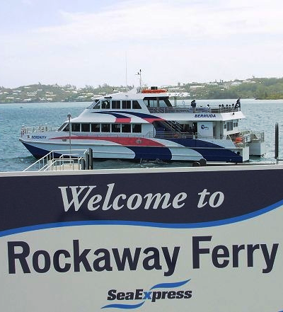
![]()
Operated by the Bermuda Audubon Society. Has an interesting pond.
![]()
![]()
![]()
Nature reserve.
2016. December 5. A tribute now stands to the late former Chief Justice Sir Richard Ground, whose love of nature has been celebrated with a bird hide shelter in his name at the Seymours Pond nature reserve. Sir Richard served as Bermudas Chief Justice from 2004 until his retirement in 2012. His passion for wildlife and talent as a photographer resulted in the publication of the books Creators Glory when he was Attorney-General in the Cayman Islands, and The Birds of the Turks and Caicos Islands during his tenure as Chief Justice in Turks and Caicos Islands. The Bermuda Audubon Societys reserve in Southampton has been extensively upgraded, and Sir Richards widow, Lady Ground, was able to visit the bird hide last week during a visit to the island. Society president Andrew Dobson called it a fitting tribute to a man who would undoubtedly have spent many hours here with his camera at the ready. About 100 species of birds have been recorded on the nature reserve, and the hide provides ideal viewing of the wildfowl, herons and shorebirds that visit the pond. Lady Ground was accompanied on her visit by Audubon Society member Geoffrey Bell, who was instrumental in the creation of the bird hide, and Bermudas current Chief Justice, Ian Kawaley.
![]()
![]()
Appointed under the Parish Councils Act 1971. See under "Parish Councils" in Bermuda Government Boards. Appointees are political and meetings are not open to the public, unlike in the United Kingdom, Canada and USA where parish or community councils always are.
![]()
See Beaches.
In order of appearance, they are Port Royal, Horseshoe Bay, Peel Bay, Butt's, Middle, Wafer Rocks, Angle, Hidden, Chaplin Bay and Jobson's Cove. South of the Lighthouse, off the South Shore, Horseshoe Bay has a quarter mile of curved pink sand fringed by limestone cliffs and a park setting north of it. There is a life guard. Get there by bus (number 7 stops on the main road) and then via a walk or a moped or taxi or car, up and down a steep hill. Peel Bay is just east of and may be accessed via Horseshoe Bay. It is its equal in many respects of its bigger adjacent brother but without the same facilities. Chaplain Bay got the name from the fact that some chaplains, conducting beach side weddings in this perfect spot for such solemn ceremonies, have been known to cast their eyes upward to their Maker and intone with great reverence that this is the part of Heaven they trust will be reserved for them.
![]()
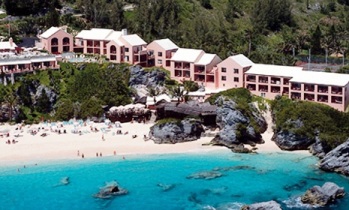 South
Road, Southampton Parish.
Phone (800) 742-2008 in the USA or Canada or directly at (441) 238-0222. Fax
(441) 238 8372. E-mail reefsbda@ibl.bm.
Taxi fare from/to airport from $35 per taxi for 1-4 passengers or from $45 for
5-6 passengers.
South
Road, Southampton Parish.
Phone (800) 742-2008 in the USA or Canada or directly at (441) 238-0222. Fax
(441) 238 8372. E-mail reefsbda@ibl.bm.
Taxi fare from/to airport from $35 per taxi for 1-4 passengers or from $45 for
5-6 passengers.
A beach resort nestled into coral cliffs above a private pink beach with good diving and snorkel facilities. Each guest room has Bermuda-inspired colors. Each private lanai is situated to give maximum privacy. With three gourmet restaurants, bar and fitness center. The 2 tennis courts are plexi-pave. On the 7 bus route. Owned by David Dodwell, a former Minister of Tourism for the United Bermuda Party. (He also owns a hotel on the island of Nevis, Caribbean).
It applied for and got major renovations under the Hotels Concessions Act and has invested US$5 million on renovations and additions. It has new suites, entrance area, landscaping and first "infinity" hotel swimming pool in Bermuda. The USA's Travel & Leisure magazine voted this hotel as best in in the Caribbean region for the standard of its rooms, facilities, service, food, restaurant and value - and 23rd best in the world. in June 2007 work started on a $40 million dollar new development, The Reefs Club. It is a Private Residence Club (PRC) with 19 two-and-three bedroom residences all with unobstructed ocean views and will feature a spa on the patio of every unit.
Residents also have access to an infinity pool, whirlpool, club lounge and state-of-the-art fitness centre.
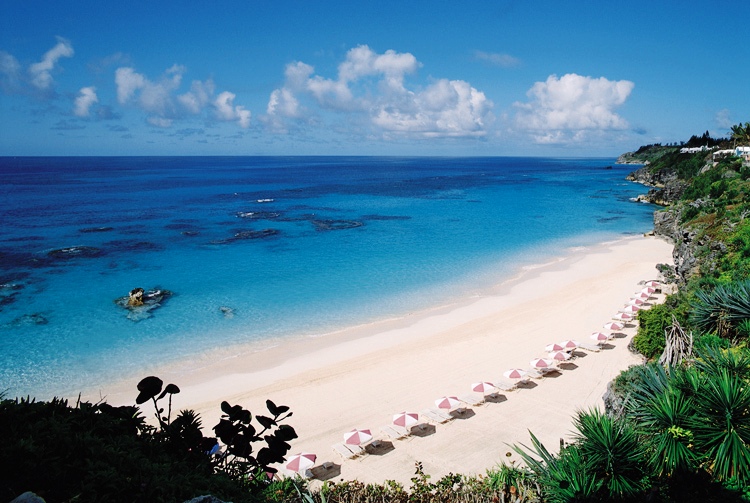
The Reefs beach
The PRC is located immediately west of The Reefs property. The PRC units are fractionally owned, meaning there will be ten owners per unit. When a unit is purchased the owners get to select the dates they will be residing there, but also have the right to use the unit whenever it is free. Owning at a luxury fractional development such as this is essentially the only feasible way for foreigners to own real estate in Bermuda, due to a government policy that restricts the amount of real estate that can be sold to non-Bermudians. Because of their affiliations with hotel properties, private residence clubs are not affected by these regulations.
![]()
Not accessible by the general public. Shown here for historical purposes only.
Left on Pompano Beach Road after Port Royal Golf Course, then left again to facility. It had 25 acres going down to the South Shore ocean. It was a top secret anti-submarine warfare and radar surveillance station. It dated from it's official operational beginning on June 1, 1955, making it the oldest continuously operating U.S. command at the time of its decommissioning. NAVFAC was located on the west end of Bermuda in Southampton Parish, adjacent to the islands very scenic south shore. NAVFAC experienced numerous composition and equipment upgrades during its long operational tenure. In September, 1987, NAVFAC Bermuda weathered Hurricane Emily, with no loss of operational capability. NAVFAC Bermuda had fifteen officers, 155 enlisted personnel, 2 foreign national civilians and one resident contractor.
Tudor Hill was a secret U.S. communications base located in Southampton Parish next to Port Royal Golf Course. The 25 acre site, part of a $16 billion worldwide US Navy listening complex called Sound Surveillance System, was the site of a hi-tech Cold War listening device that spread out on cables along the seabed from Bermuda as far as Iceland. Before the Navy pulled out of Bermuda, Tudor Hill was the centre for a series of deep ocean microphones used to listen for Soviet submarines.
Naval Facility Bermuda, or NAVFAC Bermuda, was the operational shore terminus for one of the Atlantic Sound Surveillance System (SOSUS) array systems installed during the first phase of system installation and in commission from 1955 until 1992. The true surveillance mission was classified and covered by "oceanographic research" until the mission was declassified in 1991. The system's acoustic data was collected after the facility was decommissioned until the system was routed to the central processing facility, the Naval Ocean Processing Facility (NOPF), Dam Neck, Virginia in 1994. The operational surveillance facility was often confused with the adjacent research facility, the Tudor Hill Laboratory, and its undersea sensors supporting research and development for Navy acoustic systems. That laboratory was the only such research and development facility with access to an operational surveillance facility. When that laboratory, then a detachment of the Naval Underwater Systems Center, was disestablished 30 September 1990 its facilities were assigned to the Naval Facility which was then decommissioned two years later.NAVFAC was a shore terminus for SOSUS arrays commissioned 1 June 1955 as part of the first phase of Atlantic installations. The facility's mission was classified until 1991 when the cover story of "oceanographic research" was revealed as "surveillance." The facility, with fifteen officers, 155 enlisted, two local civilian employees and resident contractor, was upgraded numerous times over its operational life of thirty-seven years. NAVFAC Bermuda was decommissioned as a command 30 September 1992. In 1994 the acoustic data from the system itself was routed directly to the Naval Ocean Processing Facility (NOPF), Dam Neck, Virginia. There was some hope that the base would survive the end of the Cold War, and the base closures of 1995. It was thought that it might be adapted to scientific purposes, for the monitoring of whales, but it was closed, instead, along with NAS Bermuda, and the NAS Annex.NAVFAC Bermuda was often associated with and confused with the adjacent Naval Underwater Systems Center's Tudor Hill Laboratory which was engaged in acoustic research. The laboratory was a major facility and operated a number of acoustic research systems off Bermuda and the R/V Erline. The laboratory was built in the early 1960s as the Bermuda Research Detachment to support Project Artemis and Project Trident, an investigation into ocean acoustics that included a bottom mounted vertical array.
Among the better known facilities of the laboratory was the Argus Island platform built for Project Artemis. The Tudor Hill Laboratory was the terminus for a number of undersea systems supporting both passive and active sonar development and environmental and oceanographic acoustical research with shore facilities also available to visiting researchers of Navy projects with suitable clearances and funding. The laboratory was the only Atlantic Navy research and development facility with direct access to an operational SOSUS facility allowing studies and evaluation of operational hardware. When the Naval Underwater Systems Center (NUSC) detachment and Tudor Hill Laboratory on Bermuda were shut down 30 September 1990 the facilities were transferred to the Naval Facility with the understanding that NUSC would be provided support should a research need arise.
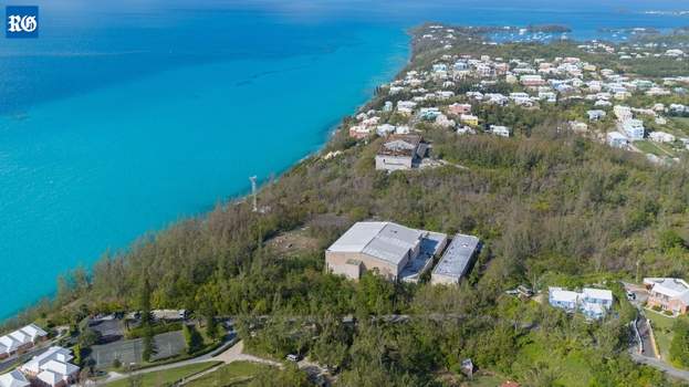
US Navy Buildings at Tudor Hill, Southampton
2018. August 13. A former Cold War base set up to track Soviet submarines could be getting a new lease of life. Several new uses for the former US Navy station at Tudor Hill in Southampton have been proposed to the Bermuda Land Development Company. A spokeswoman for the BLDC said: In February, we received numerous submissions from interested parties in response to our advertised Expression of Interest. BLDC has met with various community stakeholders who have provided their input in regards to any potential development opportunities of the 25-acre property. BLDC has been meeting with each of the respondents to discuss how their proposals could potentially fit into the site plan, and we are currently assessing the feedback received from them so that we can make a determination of the best suited proposal for the area. The property, next to the Pompano Beach Club, was home to a US Navy base until the 1990s but has since become derelict. The base was part of the Sound Surveillance System, Sosus, a deep-sea network of listening posts designed to track the movements of Soviet Navy submarines in the Atlantic. The base closed in 1992 after 37 years of operation and the land was handed back to the Bermuda Government three years later. Pompano Beach Club expressed interest in buying the land for expansion in 2013 but the plan was later dropped
2018. January 19. A former Cold War submarine tracking base is in line to get a new lease of life. The Bermuda Land Development Company has asked for expressions of interest to redevelop the ex-US Navy site at Tudor Hill in Southampton. Francis Mussenden, chief executive office at the BLDC said: Were looking for innovative and imaginative development approaches that align with our long-term strategy to revitalize Tudor Hill. The BLDC said the Exchange of Information was designed to gather ideas and approaches for development. Once a preferred use or development idea has been selected, a request for proposal could be submitted. Kim Smith, executive director for the Bermuda Environmental Sustainability Taskforce said: BEST supports sustainable development, recognizing that preserving finite and precious virgin land in Bermuda is always a perfectly acceptable and valuable option. We will look forward to the BLDC keeping the public apprised of the process. Jonathan Starling, executive director of environmental charity Greenrock, added he hoped that any development allowed the Tudor Hill Marine Atmospheric Observatory to continue to operate on the site. He said: The observatory is one of the longest-running centres of atmospheric ocean chemistry in the world, providing world-class research. While the research in itself may not be profitable in the short-term sense, the research conducted there is invaluable to the advancing of human knowledge in the field of oceanic atmospheric studies. Mr Starling said a solar farm could be a useful addition to the site, along with a memorial to detail its long military history. He added: Tudor Hill was the site of fortifications throughout its history and the ruins of these forts remain. We could see a tourism attraction there along these lines, along with a solar farm and the continued use of the site for scientific research. The 25-acre site, next to the Pompano Beach Club, was once home to a US Navy detachment and part of the Sound Surveillance System, known as Sosus. Sosus monitored a deep-sea network of listening posts to track the movement of Soviet submarines in the Atlantic. Tudor Hill remained in service until the end of the Cold War in the early 1990s. It closed in 1992 after 37 years of operation and the land was handed back to the Bermuda Government three years later. Pompano Beach Club expressed interest in buying the land for expansion in 2013, but the plan was later dropped. Anyone interested in the site should contact info@bldc.bm or visit the BLDC office at Triton House in St Davids to pick up a copy of the EOI guidelines, which detail the requirements and selection criteria. All submissions must be received by 4pm on Thursday, February 8.
1995. The facility closed. There was some hope the base would be adapted to scientific purposes for monitoring whales but this never happened
1955. June 1. The Naval Underwater Systems Centre: Tudor Hill Laboratory based in Bermuda opened. This was the official name for a secret facility and bunk designed to listen for Soviet submarines. There was never much information about the facility when it was in operation because of the top secret intelligence work taking place. During the Cold War, the threat of close range nuclear attacks on Washington DC by using submarines was a real threat. Bermuda was in an ideal location to track Soviet Union submarines enroute to Cuba or the American East Coast.
![]()
Where the Fairmont Southampton Princess Hotel was built. Before that, it was once owned by Sir Nathaniel Rich, one of the original directors and shareholders of the Bermuda Company, from 1615 until his death in 1636. On 7th April 1941, the American Army took it over. The American leader, Captain (later Admiral) Jules James USN received commendations for his careful and diplomatic handling of the Bermuda Government and the people of the island, unlike the-then Governor of Bermuda. In another connection with Bermuda, Capt. James was a cousin of Nancy Astor, the first woman elected to the Parliament in London; she was married to a relative of one of the richest men in the world, Vincent Astor, who built a great home on Ferry Reach. (Astor erected the house with his first wife, Helen Huntington, but both likely lost interest in it when the pristine Castle Harbour, their main vista, was destroyed to make Kindley Field). One of the Americans who came to Bermuda at that time was a Captain Charles Beaudry USA, who spent most of the war in Bermuda.
He made friends with many Bermudians, and made many pictures of the island, the new military works and Bermuda scenes of the time. Captain F. W. Clipper was another US Army officer in Bermuda and often at this location at that time. He too stayed in Bermuda, married into a local family and subsequently contributed hugely to the social benefit of Bermuda. Colonel Beaudry later donated his photographic collection to the Bermuda Maritime Museum which has an archive of American activity on the island during the war. By 1939, the several hundred British guns at Bermuda had been reduced to two 6-inch Breech Loaders manned by the Bermuda Militia Artillery at St. David's Battery. Two more such guns were installed that year at Warwick Camp, but with only four weapons island-wide, the Americans willingly assume the coastal defence of Bermuda and brought in some big guns. Captain Beaudry was in charge of installing some, two of which were at Turtle Hill, where a camp was soon installed amidst the rolling cedar strewn landscape. On the highest part of the hill, two circular Panama Mounts were built in concrete to take 155mm GPF guns.
Similar guns were placed at Cooper's Island, while massive railway guns, mounted on a set of tracks, were installed at Scaur Hill and between Forts Victoria and Albert on St. George's Island. A year later, fixed installations replaced the latter and two others were built at Tudor Hill near the Naval Operating Base, where Captain Jules James set up camp at the first American station in Bermuda. At the American Army encampment at Turtle Hill, the facilities included an open-air mess hall. See the surviving Panama Mount gun emplacement which once had a 155mm GPF gun.
![]()
Part of, owned and operated by and adjacent to the Fairmont Southampton Princess Resort complex, South Road, Southampton Parish SN 02. For reservations call (441) 238-0446. An 18 hole par 54 course over 2,684 yards. Carts are mandatory and included in the green fees. There's a pro shop, tennis courts, bar and restaurant. For visitors who arrive on one of the cruise ships, the closest cruise ship berth used to be (until 2007) the City of Hamilton, about 5 miles away to the east, but is now Dockyard, about 8 miles away. If you bring your own clubs, you won't be able to go by public transportation (bus). Instead, take a taxi. Buses (# 7 or 8) go only to nearest stop about half a mile away below the hill. Check rates directly with course depending on time of day and time of year.
Private but will accept off-the-street golfers by prior appointment.
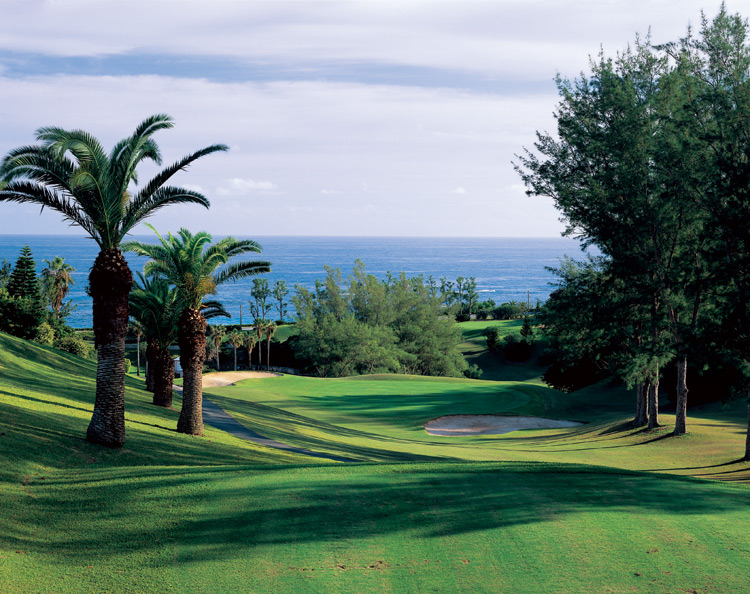
Photo: Bermuda Tourism
![]()
Off Middle Road, between Evans Bay Road and Rockaway. It includes part of the valley containing Evans Pond and a ridgeline extending all the way to the Little Sound. The eight-acre Nature Reserve has been saved from future development thanks to the generosity of Sharon Vesey, who donated the site to the Buy Back Bermuda group. The organization a joint initiative of the Bermuda National Trust and the Bermuda Audubon Society has renovated the area, which includes two quarries, a natural limestone sink hole and a variety of habitats, including mangroves, a lush woodland valley, an exposed hilltop and rocky shoreline. A great deal of work has gone into its restoration, making it a wonderful place for a family day out. Amenities include walking trails, interpretive signs, a quarry exhibit, plenty of places to picnic and for children to play, benches to relax on and an observation platform with a fabulous view of the Sound. Much of the reserve restoration was carried out by teams of volunteers from HSBC, Butterfield Bank, Lancashire Re and Bermuda Audubon Society, under the direction of David Outerbridge of the National Trust and David Wingate of the Audubon Society. The volunteers culled thousands of invasive plants, planted many native and endemics and helped to clear pathways. The reserve features a number of interpretive signs and a quarry exhibit with an authentic five foot quarry saw. This is the second nature reserve opened to the public through the Buy Back Bermuda campaign. Six years ago, it opened the Somerset Long Bay East Nature Reserve. And a third project is in the pipeline after the group bought up another piece of open space, Evas Pond, in Hamilton Parish.
![]()
![]()
| City of Hamilton | Hamilton Parish | Paget Parish | Pembroke Parish | Sandys Parish | Smith's Parish |
| Southampton Parish | St. David's Island | St. George's Parish | Town of St. George | Warwick Parish |
![]()
![]()
Banner.jpg)
Authored,
researched, compiled and website-managed by Keith A. Forbes.
Multi-national © 2020. All Rights Reserved